LOT SPLIT SURVEYS
LOT SPLIT SURVEYS
QUALITY · COMMITMENT · RELIABILITY
QUALITY · COMMITMENT · RELIABILITY
WE ARE HERE TO HELP
Contact us with any questions you have about a Lot Split Surveys.
Email us below or calls us at:
405-285-5884
Are you Needing a Lot Split?
A lot split or consolidation survey is very similar to a boundary survey. A lot split includes the splitting of a single parcel into two or more new parcels. A consolidation is essentially the reverse of a lot split by combining several parcels into a single parcel.
After performing the field work, our professional land surveyors will write new legal descriptions to parcel off or join sections of land to meet your project specifications. The new legal descriptions must meet city and county standards, and must ultimately be filed by the property owner with the county for approval.
What is the Lot Split Survey Process?
The heart of a lot split or consolidation, is a boundary survey. Gateway's land survey team takes the task of defining boundaries seriously, which is why we meticulously plan each project. Each survey is different, but the general steps for completing a lot split or consolidation are listed below:
- The first significant component of it is a title search. A successful survey needs information about deeds. Deeds will provide our team with the necessary information about the history, corners, and easements associated with the property. Deeds can be provided by the customer or our team can do research in the county registrar of deeds.
- After the research is complete, our team will plan for the field reconnaissance of the location. Many boundary lines have several different distances or calls, which is why research is such an important part of the survey. It is ideal if our team can work with the original deed. Completing “senior deed research” to obtain “intent” where there appears to be a discrepancy in the description(s) provided or physically with occupation, is an important part of the process.
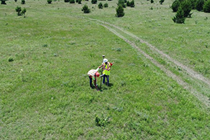
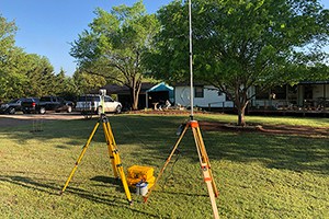
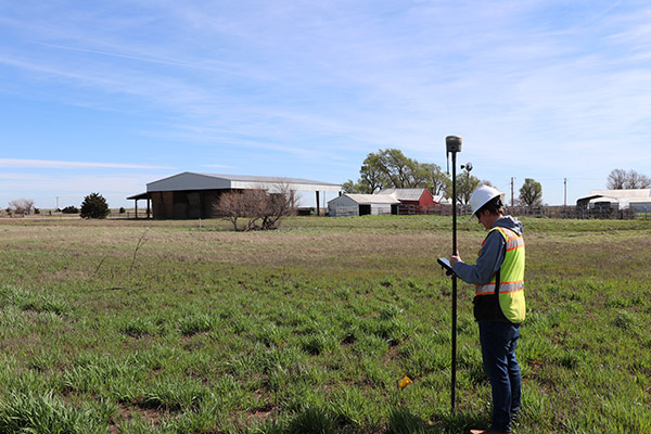
- The largest component of a boundary survey is the field reconnaissance. During the fieldwork, our land surveyors explore the property and mark the corners, gathering all the information needed to complete the drawing. A lost split survey can be paired with a topographic survey as well, if property elevations are needed for future construction planning.
- After the field work is completed, our team will review, analyze and validate the data to ensure the field work is mathematically accurate. At this time, we will determine acreage, encroachments, corner locations, easements, rights of way, and various other aspects associated with the property.
- Once the data analysis and prep is finalized, we will begin drafting the lot split or consolidation plats. Gateway always ensures that we are preparing plats so that other land surveyors can verify the findings in the future. The plat is a legal document that is prepared in compliance with the requirements of the state where the boundary was completed.
- The final component, needed to complete the plat and survey, is a visit back to the site of the property. The surveyor needs to mark the property corners and lines clearly for the property owners. The markings also serve as a sign to people that the land has been officially surveyed.
What are the Potential Complications of an Poorly Conducted Survey?
An unreliable survey can have serious consequences now, and in the future. Once filed, a boundary survey is a legal document, so it must be done carefully and by a licensed professional. If your neighborhood or property experienced a poor boundary survey the consequences could include:
- Adjacent landowners disputing boundaries
- Violation of local codes concerning building or improvement of the parcel
- Potential title defects and transfer of ownership
What is the Cost of a Lot Split/Consolidation Survey?
The cost of the survey is different for each project. Some of the things that could affect the cost include:
- The amount of parcels being split or consolidated
- The location, accessibility, and ruggedness of the parcel of land you want surveyed.
- The shape and size of the surveyed parcel of land.
- Seasonal variations in important features of the land such as leaf cover or ground markings.
- "Riparian Rights" or issues arising from properties along water.
Lot Split Plat Map Example

WE ARE HERE TO HELP
Contact us with any questions you have about a Lot Split/Consolidation Surveys.
Email us below or calls us:
Are you Needing a Lot Split or Consolidation?
What is the Lot Split/Consolidation Survey Process?
The heart of a lot split or consolidation, is a boundary survey. Gateway's land survey team takes the task of defining boundaries seriously, which is why we meticulously plan each project. Each survey is different, but the general steps for completing a lot split or consolidation are listed below:
- The first significant component of it is a title search. A successful survey needs information about deeds. Deeds will provide our team with the necessary information about the history, corners, and easements associated with the property. Deeds can be provided by the customer or our team can do research in the county registrar of deeds.
- After the research is complete, our team will plan for the field reconnaissance of the location. Many boundary lines have several different distances or calls, which is why research is such an important part of the survey. It is ideal if our team can work with the original deed. Completing “senior deed research” to obtain “intent” where there appears to be a discrepancy in the description(s) provided or physically with occupation, is an important part of the process.
- The largest component of a boundary survey is the field reconnaissance. During the fieldwork, our land surveyors explore the property and mark the corners, gathering all the information needed to complete the drawing. A lost split survey can be paired with a topographic survey as well, if property elevations are needed for future construction planning.
- After the field work is completed, our team will review, analyze and validate the data to ensure the field work is mathematically accurate. At this time, we will determine acreage, encroachments, corner locations, easements, rights of way, and various other aspects associated with the property.
- Once the data analysis and prep is finalized, we will begin drafting the lot split or consolidation plats. Gateway always ensures that we are preparing plats so that other land surveyors can verify the findings in the future. The plat is a legal document that is prepared in compliance with the requirements of the state where the boundary was completed.
- The final component, needed to complete the plat and survey, is a visit back to the site of the property. The surveyor needs to mark the property corners and lines clearly for the property owners. The markings also serve as a sign to people that the land has been officially surveyed.
What are the Potential Complications of an Poorly Conducted Survey?
An unreliable survey can have serious consequences now, and in the future. Once filed, a boundary survey is a legal document, so it must be done carefully and by a licensed professional. If your neighborhood or property experienced a poor boundary survey the consequences could include:
- Adjacent landowners disputing boundaries
- Violation of local codes concerning building or improvement of the parcel
- Potential title defects and transfer of ownership
What is the Cost of a Lot Split/Consolidation Survey?
The cost of the survey is different for each project. Some of the things that could affect the cost include:
- The amount of parcels being split or consolidated
- The location, accessibility, and ruggedness of the parcel of land you want surveyed.
- The shape and size of the surveyed parcel of land.
- Seasonal variations in important features of the land such as leaf cover or ground markings.
- "Riparian Rights" or issues arising from properties along water.
Click the Image to Below See a Lot Split Plat Map Example
405-285-5884

"*" indicates required fields